MAT200A 03W |
Ceretha McKenzie "image processing for remote sensing" | |
| image processing workbench (ipw) |
ipw is a unix based
image processing software package written at ucsb by
James Frew and
Jeff Dozier.
[Frew is currently on the faculty for the interdiciplanary phd program in
interactive digital multimedia]
at the time, (~ 1987) no software was commercially available to meet all their image processing needs at a reasonable price, so they wrote their own. we had one extremely expensive iis ("i squared s") system, ($100,000?) and otherwise, used main frame based sofware, vicar/ibis from NASA JPL. we waited 45 minutes to walk from phelps to north hall, (hoping we hadn't left out a semicolon) to look at satellite images printed out using ascii characters with overstrikes! the geography department decided to use ipw in it's remote sensing and digital image processing class, and for my masters project, i wrote portions of the software that were required for the class. (c programs and unix shell scripts) ipw is command line oriented - it is completely grounded in unix - it is a modular set of image processing tools, using pipes to connect them. it is designed for and very effective for batch processing of large quantities of data. my specialty is writing unix shell scripts to use ipw to process large image
data sets, including real time downloading of satellite data from a receiver
on the roof of ellison hall.
|
|
|
ipw's user interface |
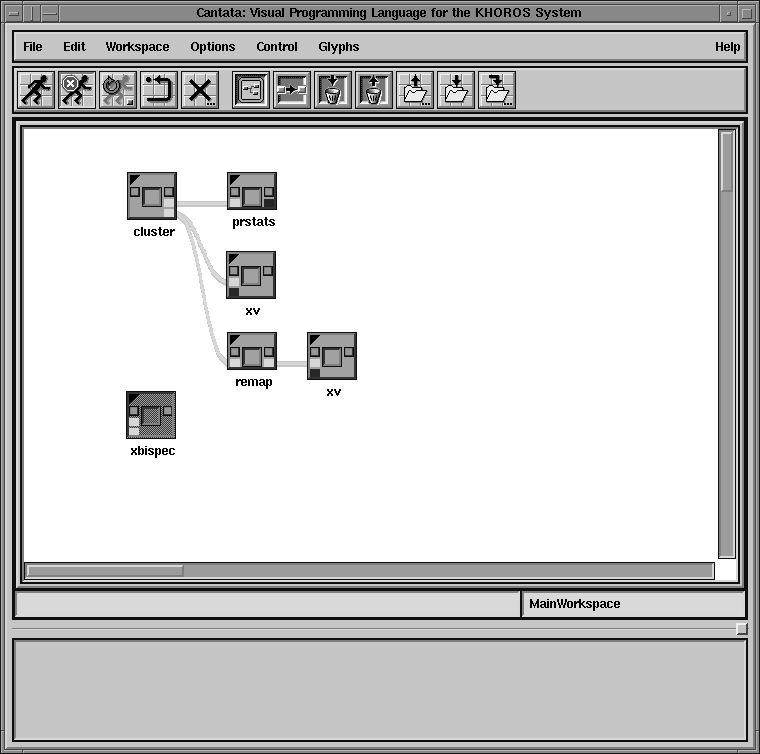
ipw's user interface is state of the art early 80's (or 70's?) and you would never want to point and click your way through the quantity of images i process in ipw. after a few years of using ipw in the remote sensing class, i wrote a prompting user interface for ipw, and a few years later, integrated ipw into cantata, a gui for khoros, an amazingly similar image processing system developed at the university of new mexico. (by more than 3 people...) both of these user interfaces are optional layers to ipw. i can still have my command lines to incorporate into my shell scripts, and students can have either a prompting command line interface, or a full on gui (cantata). over the past several years of teaching lab classes in remote sensing, i've often been surprised by how different students work, and when given choices about the user interface, which choices they make.
|
|
|
|
|
|
|
examples
|
student's experiences with ipw user interfaces: cantatain the first quarter class, the software is taught using the prompting interface, and in the second quarter, we introduce the gui, cantata. while most of the class prefer using cantata, i am often surprised by which students chose not to use it - when grad students, and computer science majors don't like cantata, it doesn't surprise me, but there have been students who are not particulary computer literate who prefer to use the command line prompts. xv
we use an image display program with ipw called xv,
written by John Bradley at the university of pennsylvania.
i've written code into xv to save the corner coordinates of rectangles and polygons to a file (required for image classification) in the labs, we offer 2 methods for saving the corner coordinates: . write down the coordinates, and type them back into a prompting program . save them directly from xv to the file the choice is obvious, right... who would want to type in numbers when they can just automatically save them? about half the class.... what's going on here? i've talked to students about this, and they feel more in control of what's going on when they write down the numbers, and type them in.
these experiences have taught me that there are many ways people perceive and learn, and maintaining as much flexibility in user interfaces is crucial.
|
|
|
ipw today
|
it's not the 80's anymore, why am i still using ipw today?
now, there are 2 commercialy available remote sensing image processing software packages available, ERDAS Imagine, and ENVI. they are still relatively expensive ~ $3000, although affordable for universities. (while there's some overlap with photoshop, this is not something that can be done in photoshop - for example, we have 5, 7, 8, or 224 spectral channels, not just rgb) 4 features of ipw have kept it 'alive' for all these years. . ipw contains some terrian modelling programs written by Jeff Dozier that are not available in any other image processing system. (i still receive emails from strangers from various parts of the world requesting help with this software) . professor Leal Mertes, who teaches the geography department remote sensing courses, believes that ipw is a better educational tool - she believes that ipw requires students to understand more about the concepts of what they're doing than gui based systems like envi or imagine. . it's portable among unix systems (it runs on sun, dec, sgi, and linux - mac os x is my next project) . it's free. i've also heard of some interest in using ipw for web based server side processing - for users who want to use remote sensing images, but don't want to purchase expensive software like envi or imagine.
|